Japanese Territory
Q&A About the Takeshima Dispute
- Q1In international law, does geographical proximity of an island to a nation's territory have any significance with regard to sovereignty over that island?
- Q2Is Takeshima mentioned in Korean period documents or maps in the ROK?
- Q3What sort of person was Ahn Yong-bok?
- Q4Prior to the Japanese government's incorporation of Takeshima in 1905, is there any proof that Korea owned the islands?
- Q5Was Takeshima included in the “territories which Japan has taken by violence and greed” in the Cairo Declaration?
- Q6Was Takeshima placed outside Japanese territory by SCAP after World War II?
Q1In international law, does geographical proximity of an island to a nation's territory have any significance with regard to sovereignty over that island?
A1The Republic of Korea (hereafter, ROK) alleges that the geographical proximity of Takeshima to Utsuryo Island proves that Takeshima is geographically part of Utsuryo Island. However, in international law, geographical proximity itself has no significance with regard to territorial sovereignty. This understanding is apparent in precedents set by international courts.
For example, back in the 1920s, when the United States and the Netherlands disputed sovereignty over the Island of Palmas, the Arbitration court ruled: “The title of contiguity, understood as a basis of territorial sovereignty, has no foundation in international law….” Furthermore, recently, in its Judgment in the Case concerning the Territorial and Maritime Dispute between Nicaragua and Honduras in the Caribbean Sea (2007), the ICJ did not recognize the geographical proximity that Nicaragua claimed should be involved as an element in determining sovereignty over maritime features of the disputed area. Additionally, in the case concerning the dispute over the islands of Ligitan and Sipadan between Indonesia and Malaysia (2002), the ICJ rejected the contention of Indonesia that the two islands, 40 nautical miles from an island in regard to which sovereignty was not disputed, were islets belonging to it.
Q2Is Takeshima mentioned in Korean period documents or maps in the ROK?
A2No. While the ROK claims that the Usan Island listed in their period documents and maps is the current Takeshima, there are no grounds for this claim.
Period documents that the ROK claims as proof:
The ROK claims, using Korean period documents, that it has been aware of the two islands of Utsuryo Island and Usan Island for centuries, and that Usan Island is none other than the current Takeshima. However, no proof has been found for the ROK's claim that the Usan Island in Korean period documents is in fact the current Takeshima.
For example, in Sejong Sillok, Jiriji (Geography Section of the Annals of King Sejong's Reign: 1454) and Sinjeung Dongguk Yeoji Seungnam (Revised and Augmented Edition of the Survey of the Geography of Korea: 1531), the ROK claims that the two islands of Usan and Utsuryo are listed as being in the sea to the east of the prefecture of Uljin, which means that this Usan Island is Takeshima. However, Sejong Sillok, Jiriji notes that “In the Shilla Period, it was called Usan Province. It was also called Utsuryo Island. The land is a hundred square ri.” (新羅時称于山国一云欝陵島地方百里), and in Sinjeung Dongguk Yeoji Seungnam it is referred to in the following: “In one theory, Usan and Utsuryo are originally the same island. Its area is a hundred square ri." (一説于山欝陵本一島地方百里). These documents do not contain anything specific regarding Usan Island; they contain only writings concerning Utsuryo Island. There are also Korean documents that clearly show that Usan Island is not the current Takeshima. For example, Volume 33 of the Annals of King Taejong, covering February of the 17th year of his reign (1417), contains the statement that “Royal Inspector Kim In-u returned from Usan Island and brought local products as tribute, including large bamboos […]. He also brought back three residents of the place. There were about fifteen families living on the island for a total of 86 men and women.” (按撫使金麟雨還自于山島獻土産大竹水牛皮生苧綿子撿撲木等物且率居人三名以来其島戸凡十五口男女并八十六) However, there is no bamboo on Takeshima, nor could 86 people live there.
The ROK claims that the Dongguk Munheon Bigo (Reference Compilation of Documents on Korea: 1770) and other documents which state “Utsuryo and Usan are all land belonging to Usan Province, and Usan is called Matsushima in Japan,” but these documents dating from the 18th century or later are based on an unreliable statement by a man named Ahn Yong-bok who had illegally entered Japan in 1696 (refer to Q&A (3)). In addition, although editors of documents in the 18th and 19th centuries may have written “Usan is called Matsushima in Japan,” this does not mean that the “Usan” mentioned in the 15th century Sejong Sillok Jiriji (Geographical Appendix to the Veritable Records of King Sejong) or the 16th century Sinjeung Dongguk Yeoji Seungnam (A Revised Edition of the Augmented Survey of the Geography of Korea) is in fact Takeshima.
Period maps that the ROK claims as proof*:
The ROK also insists that Korean maps dating from the 16th century show Takeshima as Usan Island, but the Usan Island shown on Korean maps to date is not Takeshima.
* Note that in terms of international law, maps that are not associated with treaties are not considered to be a basis for territorial claims, and even maps associated with treaties have only a supplementary meaning as the intent of the treaty signers is expressed in the main text.
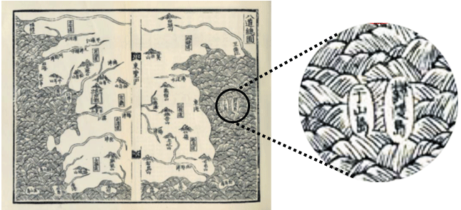
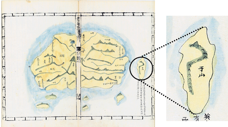
For example, the map attached to Sinjeung Dongguk Yeoji Seungnam (Revised and Augmented Edition of the Survey of the Geography of Korea), “The Map of Eight Provinces of Korea,” shows the two islands of Utsuryo Island and “Usan Island.” If “Usan Island” is assumed as Takeshima, as the ROK claims, then this island should have been depicted as an island far to the east of, and much smaller than, Utsuryo Island. However, the “Usan Island” in this map is between the Korean peninsula and Utsuryo Island, and is shown to be about the same size as Utsuryo Island. Therefore, the “Usan Island” in the Map of Eight Provinces of Korea is either Utsuryo Island shown as two islands, or a non-existent island, and not Takeshima, which is far to the east of Utsuryo Island.
▲Revised and Augmented Edition of the Survey of the Geography of Korea
The Map of Eight Provinces of Korea (Copy)
In maps of Korea dating from the 18th century, Usan Island appears to the east of Utsuryo Island. However, this Usan Island is not the current Takeshima.
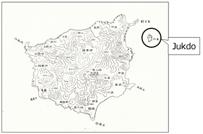
For example, in the Utsuryo Island Map connected with Bak Seok-chang's inspection tour of Utsuryo Island in 1711, “Usan Island” is shown to the east of Utsuryo Island, but there is a note there that reads “the so-called Usan Island, field(s) of haejang bamboo.” This haejang bamboo or “Simon bamboo” is a type of bamboo grass, but as the rocky islands of Takeshima are unable to grow this sort of vegetation, this Usan Island cannot be Takeshima. Note that haejang bamboo grows on Jukdo,* an island about 2 km to the east of Utsuryo Island. This suggests that the “Usan Island” shown in the Utsuryo Island Map is in fact Jukdo.
Note: Jukdo is a small island about 2 km east of Utsuryo Island
▲Survey Map of Utsuryo Island by the Navy Hydrographic Department
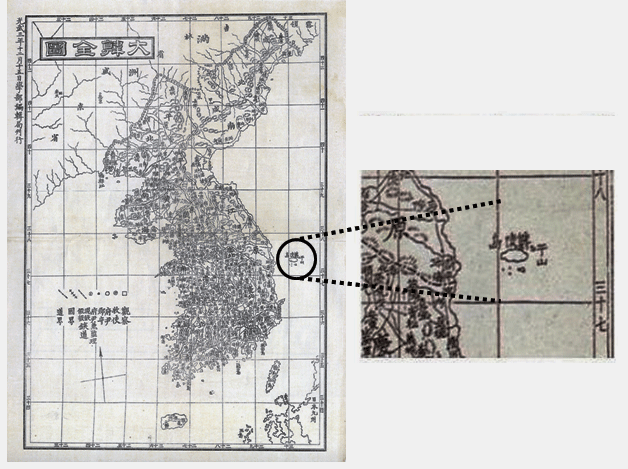
The noted Korean cartographer, Kim Jeong-ho, created a map called the Cheonggudo in 1834, which in the Utsuryo Island Map shows a long, narrow island called “Usan” to the east of Utsuryo Island.
This map includes distance markings (one distance marking is ten Korean ri, about 4 km) on all four sides, so distances are clear. From the fact that the island is only shown about 2 or 3 km from Utsuryo Island, and from its shape, it is clearly Jukdo, which is about 2 km to the east of Utsuryo Island (and not Takeshima, which is about 90 km away).
In other words, the “Usan” shown on maps of Korea from the 18th century is probably Jukdo.
▲Utsuryo Island Map from the Cheonggudo (1834) (Copyright Tenri Library, Tenri University)
Maps which showed Jukdo, about 2 km to the east of Utsuryo Island, as “Usan” were created in the modern era. The Daehanjeondo, printed by the Academic Editorial Bureau of the Korean Empire in 1899, is a modern map with lines of latitude and longitude, and it too shows “Usan” right by Utsuryo Island. This “Usan” is also Jukdo, and not the current Takeshima.
▲Daehanjeondo
(Photograph courtesy of Toyo Bunko)
Q3What sort of person was Ahn Yong-bok?
A3Ahn Yong-bok was a Korean man who set out to go fishing at Utsuryo Island (which was called “Takeshima” in Japan at the time) in 1693, was taken to Japan by the Ohya family, and who then returned to Japan of his own volition in 1696 to sue Tottori Domain. However, after that, he was arrested and interrogated by the Korean authorities for leaving the country without permission. Under interrogation, Ahn said that he met Japanese on Utsuryo Island and accused them of infringing the border, and that,having heard Japanese were living on Matsushima, he considered Matsushima to be Jasan Island, which was also Korean territory. This is how the story later developed in Korean documents that Usan Island and today's Takeshima (or “Dokdo” in Korean) were connected.
The ROK uses this statement by Ahn Yong-bok as one of its proofs of sovereignty over Takeshima.
This statement by Ahn Yong-bok was recorded in the Annals of King Sukjong in the 9th month of the 22nd year of the reign of King Sukjong (1696). However, the same document (for February of the following year) records the repudiation by the Korean dynasty of Ahn's actions, and so we can see that Korea recognized that his actions did not represent Korea (See Supplemental 1). In addition, there are a number of aspects in his statement which do not match the reality, so it lacks credibility (See Supplemental 2).
◎Supplemental 1: Ahn Yong-bok does not represent Korea.
It is clear from the following points that Ahn Yong-bok did not represent Korea.
Ahn Yong-bok's trip to Japan is evaluated as follows in the Annals of King Sukjong.
“The Dongnae government official Yi [Sejae世載] told the king that the emissary from Tsushima asked, ‘A man of your country attempted to charge us with a complaint: is this the doings of your court?’ (去秋貴国人有呈単事出於朝令耶). In response to this, Yi stated that ‘If there is something to explain here, an official interpreter will be sent to Edo, and there is no reason we would send a fisherman, as if we were afraid (若有可弁送一訳於江戸顧何所憚而乃送狂蠢浦民耶). […] The Border Defense Council of Joseon stated that ‘…the government of Korea has nothing to do with what ignorant people who are blown by the winds may say.’ (…至於漂風愚民設有所作為亦非朝家所知) The reply to this effect to the Tsushima emissary was conferred over, and the king gave his consent(請以此言及館倭允之).” (From Sukjong 23rd year)
The Korean dynasty’s repudiation was passed on to Japan in a letter sent to the lord of Tsushima Domain from Yi Seon-bak, Deputy Vice-Minister for Protocol:
“With regard to the man who drifted ashore last year, those who live on the seaside make their living sailing, and when caught in a storm, they are immediately driven before the waves to arrive at your country (昨年漂氓事濱海之人率以舟楫為業颿風焱忽易及飄盪以至冒越重溟轉入貴国). [..] If there was a charge laid by him, he committed crime of forging a letter (…若其呈書誠有妄作之罪). Therefore we have already exiled him in accordance with the law (故已施幽殛之典以為懲戢之地).”
Note: Tsushima Domain was the only official route for diplomacy and trade between Japan and Korea in the Edo period.
Ahn Yong-bok’s boat was flying a flag which read “Taxation General of the Two Islands of Utsuryo Island, Joseon. Vassal Ahn on Board,” and Ahn styled himself “Tax Inspector for the Two Islands of Utsuryo and Usan.” This title was made up, and Ahn himself admitted this identity fraud. The “Tax Inspector” or “Auditor-General” that Ahn Yong-bok called himself referred to a tax collector for the islands of Utsuryo and Usan. Ahn apparently believed that Usan Island was a large populated island.
◎Supplemental 2: Credibility of Ahn Yong-bok's statements
There are numerous discrepancies in Ahn Yong-bok's statements, making themunreliable.
Ahn Yong-bok came to Japan twice. The first time was in 1693, when he was taken to Japan as proof that there was no fishing to be had around Utsuryo Island (called “Takeshima” in Japan at the time). The second time was in 1696, when he smuggled himself to Japan to lodge a protest with Tottori Domain, and was expelled by the domain. Ahn’s statements recorded in the Annals of King Sukjong are a summary of the written statements made when he was interrogated by the Border Defense Council of Joseon on his return. According to this summary, when Ahn first came to Japan, he obtained a letter from the shogunate stating that Utsuryo Island and Usan Island were Korean territory, but Tsushima domain took it from him. However, negotiations between Japan and Korea over fishing around Utsuryo Island began when Ahn was taken back to Japan and repatriated via Tsushima Domain, so the Tokugawa shogunate would never have given him a letter saying that Utsuryo Island and Usan Island were Korean territory when he came over in 1693, before such negotiations were started.
In addition, when Ahn Yong-bok came to Japan in May 1696, he stated that there was a large number of Japanese on Utsuryo Island. However, in January, the sea travel licenses granted to the Ohya and Murakawa families were repealed, because the shogunate had already decided to ban passage to Utsuryo Island and passed the directive on to Tottori Domain. The ROK claims that the shogunate decided to forbid travel to Utsuryo Island as a result of Ahn’s visit to Japan in 1696, but Ahn arrived four months after the shogunate forbade travel to the island.
Ahn Yong-bok was interrogated on his return to Korea. It is recorded that he said to the Japanese, “Matsushima is Jasan (Usan) Island and therefore also our country’s land, why do you dare live there?” (松島即子山島、此亦我国地、汝敢住此耶). That year, there were no Japanese travelling to Utsuryo Island, so this story cannot be true. It seems that Ahn Yong-bok believed that people could live on Usan Island. When he went fishing at Utsuryo Island in 1693, he was told by his companions that the island to the north-east of Utsuryo Island was Usan Island (Takeshimakiji), and when he was taken to Japan, he said that he saw “a large island, much bigger than Utsuryo Island” (Byeonrye Jibyo). Ahn said, “Matsushima is Jasan (Usan) Island.” It is assumed that he learned the name “Matsushima” (today’s Takeshima) during his stay in Japan, and connected it with Usan Island which was traditionally drawn in Korean picture maps. However, saying that “Matsushima is Jasan Island” is, in terms of names, not actually referring to today’s Takeshima.
 Recognition of Takeshima (Recognition of Takeshima in Korea)
Prohibition of Passage to Utsuryo Island (Statement by Ahn Yong-Bok and Questions Raised)
Q4Prior to the Japanese government's incorporation of Takeshima in 1905, is there any proof that Korea owned the islands?
A4No, the ROK has not shown any proof that they owned the islands of Takeshima.
For example, the ROK states that the Usan or Usan Island appearing in Korean period documents from the Joseon period such as the "Sejong Sillok Jiriji (Geography Section of the Annals King Sejong's Reign: 1454)" and the "Sinjeung Dongguk Yeoji Seungnam (Revised and Augmented Edition of the Survey of the Geography of Korea: 1531)" is Takeshima, and so it has always been its territory.
However, “Usan” in Korean period documents and maps is either another name for Utsuryo Island, or the separate smaller island off the coast of Utsuryo Island (Jukdo), and not Takeshima.
Recognition of Takeshima (Recognition of Takeshima inKorea)
Q&A (2) Is Takeshima mentioned in Korean period documents or maps in the ROK?
The ROK insists that it established a county in Utsuryo Island by Korean Imperial Ordinance No.41 (1900), and established the area under the jurisdiction of Utsu Island County as “the entire island of Utsuryo Island and the islands of Jukdo and Sokdo (石島Ishi-jima),” and that this Sokdo is Dokdo (the Korean name for Takeshima).
However, the ROK has yet to present any clear proof that this Sokdo is in fact Takeshima. In addition, even if, hypothetically, the ordinance did refer to Takeshima, the Korean Empire never exercised actual control over Takeshima around the time of that ordinance, and so Korean territorial rights over it were never established.
Note: In 1882, the Korean dynasty abolished its “Empty Island” policy regarding Utsuryo Island, which it had maintained for 470 years, and started to develop the island. Later, in June 1900, Korea and Japan carried out a joint survey since there were a large number of Japanese residing on Utsuryo Island. The Korean Empire (Korea changed its name from Joseon to Daehan Jeguk, the “Great Han Empire,” in October 1897) enacted the imperial ordinance No.41 to rename Utsuryo Island as “Utsu Island” and to make the Island Administrator County Magistrate, based on the report of this survey (U Yong-jeong's Uldo-gi), having considered the necessity of “exchange with foreign travelers and traders”.In Article 2 of this ordinance the jurisdiction of Utsu Island County was set as “the entire island of Utsuryo Island and the islands of Jukdo and Ishi-jima.” However, it is not certain where this suddenly appearing “Ishi-jima” actually was.
According to the report of the survey carried out prior to this ordinance, the length of Utsuryo Island was 70 ri (approx. 28 km), its width was 40 ri (approx. 16 km), and its circumference was 145 ri (…全島長可為七十里廣可為四十里周廻亦可為一百四十五里). Also, it is stated, in the “Request for Cabinet Decision Regarding the Change of Name of Utsuryo Island to Utsu Island and the Change from Island Administrator to County Magistrate” (1900) by Yi Kon-ha, Minister of the Interior, that “…the area of the island concerned is 80 ri on the long axis (approx. 32 km) and 50 ri across (approx. 20 km).” From these facts, it is clear that Takeshima, about 90 km away, was outside the scope, and that Ishi-jima is not Takeshima. Given that relatively large islands exist in the area around Utsuryo Island (within a few kms of the island) called Jukdo and Gwannumdo, there is a possibility that “Ishi-jima” meant one of these islands.
1 ri (Japan) = about 10 ri (Korea) = about 4 km
Q5Was Takeshima included in the “territories which Japan has taken by violence and greed” in the Cairo Declaration?
A5No, it was not.
The ROK alleges that Takeshima falls under the “territories which Japan has taken by violence and greed” in the Cairo Declaration (1943) announced by the leaders of the United States, the United Kingdom and China during World War II. However, Takeshima has never been Korean territory, whereas Japan had established sovereignty over the islands no later than the middle of the 17th century, reaffirmed it with the islands' incorporation into Shimane Prefecture by cabinet decision in 1905, and has exercised its sovereignty peacefully and continuously. This makes it clear that Takeshima was not territory that Japan took from Korea.
The ultimate determination of territory following a war is done by a peace treaty or other forms of international agreements. In the case of World War II, it was the San Francisco Peace Treaty that legally determined Japan's territories, and the Cairo Declaration does not have any ultimate legal effect on the determination of Japanese territory. It is confirmed in the San Francisco Peace Treaty that Takeshima is Japanese territory.
Q6Was Takeshima placed outside Japanese territory by SCAP after World WarII?
A6No, it was not. SCAP had no authority regarding the disposition of territory.
The ROK claims that SCAPIN (Supreme Commander for the Allied Powers Instruction Note) No. 677 (See Supplemental 1) and No. 1033(See Supplemental 2) place Takeshima outside Japanese territory. However, both of the directives explicitly stipulate that it's not an expression of allied policy relative to ultimate determination of territory, although the ROK makes no mention of this. The Korean position is therefore untenable.
It is the San Francisco Peace Treaty (effective in 1952) that decided the territory of Japan after the War. Therefore it is clear both in terms of fact and in terms of international law that the treatment of Takeshima by SCAP before that Treaty came into force has no effect on sovereignty over Takeshima.
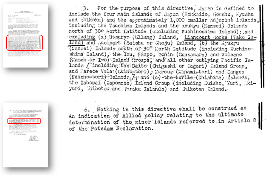
◎Supplemental 1: SCAPIN No. 677
In January 1946, the General Headquarters for the Supreme Commander for the Allied Powers ordered the Japanese government to provisionally cease exercising or attempting to exercise political or administrative authority over certain outlying areas based on SCAPIN No.677. Paragraph 3 of the directive provides that “For the purpose of this directive, Japan is defined to include the four main islands of Japan (Hokkaido, Honshu, Kyushu and Shikoku) and the approximately 1,000 smaller adjacent islands, including the Tsushima Islands and the Ryukyu (Nansei) Islands north of 30° North Latitude (excluding Kuchinoshima Island).”The directive then listed Takeshima along with Utsuryo Island, Jeju Island, the Izu Islands, the Ogasawara Islands, etc. as the areas “excluded.”
However, Paragraph 6 of the directive clearly states that “Nothing in this directive shall be construed as an indication of Allied policy relating to the ultimate determination of the minor islands referred to in Article 8 of the Potsdam Declaration.” (Article 8 of the Potsdam Declaration: “…Japanese sovereignty shall be limited to the islands of Honshu, Hokkaido, Kyushu, Shikoku and such minor islands as we determine.”) The claim of the ROK completely ignores this.
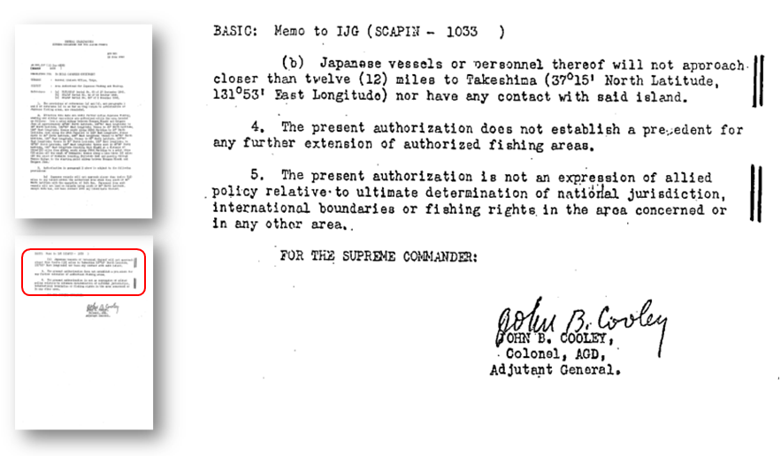
◎Supplemental 2: SCAPIN No. 1033
In June 1946, SCAP expanded the area authorized for Japan's fishing and whaling (the so-called “MacArthur Line”) by SCAPIN No. 1033. Paragraph 3 of the directive stipulates that “Japanese vessels or personnel thereof will not approach closer than twelve (12) miles to Takeshima (37°15' North Latitude, 131°53' East Longitude) nor have any contact with said island.”
However, Paragraph 5 of the directive explicitly provides that “The present authorization is not an expression of allied policy relative to ultimate determination of national jurisdiction, international boundaries or fishing rights in the area concerned or in any other area.” The claim of the ROK completely ignores this as well.
The MacArthur Line was abolished on April 25th, 1952, and with the San Francisco Peace Treaty coming into force three days later, on the 28th of April, the directives for cessation of governmental authority necessarily became invalid.