
Japan's Official Development Assistance White Paper 2012
Stories from the field 8
Satellite Data and Surveys in the Depths of the Amazon Reveal Carbon Stock
– Cooperation toward Brazilian Tropical Forest Conservation –
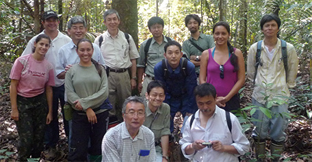
Members at the launch of the joint research project (Dr. Ishizuka (front row, first from left), Dr. Higuchi (back row, third from left), Professor Sawada (to the right of Dr. Higuchi) (Photo: Dr. Moriyoshi Ishizuka)
Called the "lungs of the Earth" the Amazon rainforest absorbs huge amounts of carbon dioxide. It is the world's largest tropical rainforest, but rampant development since the 1960s has caused the forest to decline rapidly. The decline has picked up speed going into the 21st century, and there were concerns that forests would decrease by half in the next 20 years if this trend continued.
The 13th Conference of Parties to the United Nations Framework Convention on Climate Change (COP 13) was held in December 2007 on the island of Bali in Indonesia, where REDD+ was on the agenda. REDD+ goes beyond REDD ("Reducing Emissions from Deforestation and forest Degradation in developing countries" by adding "the role of conservation, sustainable management of forests and enhancement of forest carbon stocks in developing countries.") The implementation of REDD+ can benefit the lives of local people by protecting local communities and the rights of indigenous peoples and holding back climate change and the deterioration of biodiversity through the sustainable use of forests.
However, the lack of a way to accurately measure changes in carbon stock in the forests presented a major challenge. The Brazilian government requested assistance from Japan, which had experience in measuring and researching carbon stock in forests in Southeast Asia. In March 2010, the two countries began joint research through "Carbon Dynamics of Amazonian Forests," a four-year JICA technical cooperation project.
The project is the first of its kind and consists of two teams; a Ground Team that surveys trees in over 1,000 test areas within primeval Amazonian forests, and a Remote Sensing Team that uses a satellite and aircraft to survey the same locations from the sky. Managing the entire project is Forestry and Forest Products Research Institute Doctor of Agriculture Moriyoshi Ishizuka. Dr. Ishizuka leads the Ground Team alongside Brazilian National Institute of Amazonian Research (INPA) Doctor Niro Higuchi, with whom he has done research before.
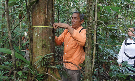
Caros recording a diameter and tree name. Called the "Tree Encyclopedia," he was able to distinguish hundreds of types of trees. (Photo: Dr. Moriyoshi Ishizuka)
The Ground Team surveyed over 10 zones in the Amazon. One zone spans dozens of square kilometers. Each survey area is 20 meters by 125 meters. More than 1,000 areas will be surveyed over four years. Each survey takes one to two months. Nearly 20 people board a triple-deck ship and sail up the Amazon River, changing to a smaller boat when they want to enter the forest. The team surveys the condition of the trees in each survey area. They measure the diameters of all standing trees (including dead ones) within the area with diameters of 10 cm or greater and the diameters and lengths of fallen trees to calculate carbon stock. They record the names of each type of tree and take specimens with them when they do not know the type. They also cut down at least 100 trees with diameters of 10 cm or greater in the upper, middle and lower Amazon River basins and measure the weights of the upper parts (including branches and leaves) and underground roots of each. Then, they take samples and measure the carbon content.
Meanwhile, the Remote Sensing Team, led by the Brazilian National Institute for Space Research (INPE) and Professor Haruo Sawada of the Institute of Industrial Science at the University of Tokyo, gathers information on the structure, geography and water levels of the forest as seen from satellites and aircraft. The Remote Sensing Team links their data to the ground-level data recorded in the forests and continues to develop a system that more accurately measures the carbon stock of the entire Amazon. Dr. Ishizuka related that gaining permission and understanding from indigenous peoples was the most important thing to be mindful of in the course of the Ground Team's surveys. "Some indigenous people have had very little contact with the outside world, so we spend the first several days talking to them," he said. "We let them lead us into the interior of the forest and maintain the survey areas."
Dr. Ishizuka continued: "The dense jungle is full of poisonous snakes, and if you are bitten, you will die. A survey team member was bitten before, but he was saved because he happened to be near the city of Manaus, where the national institute of poisonous snake is located. Since then, I have worn snake protection over my pants when I am working." The survey work has many difficulties, but there are some things in which to take comfort: "Local children come to our ship to play," Dr. Ishizuka said. "Some children cried when our work was finished and it was time for us to leave. And it is marvelous to see groups of peccaries swimming through the Amazon River and swarms of butterflies dancing through the air in the evenings."
The results of forest conservation efforts have shown in recent years, and the Brazilian government is growing more interested. INPA, by receiving JICA assistance, continues to provide training for carbon stock measurement, inviting Bolivia, Peru and other neighboring countries. "I want the results of our surveys to make the standard of Amazon carbon stock measurement spread from Brazil throughout the tropical forests of the world and to lead the world in tropical forest conservation," Dr. Ishizuka said.