
The Study of maps possessed by the British Library and the University of Cambridge
(Overview)
September 2003
- The Ministry of Foreign Affairs of Japan conducted a field study of antique maps possessed by the British Library and the University of Cambridge from October 2002 to June 2003, to examine whether the name "Sea of Japan" is recorded in the maps published in Europe between 1801 and 1861. The aim of the study was to confirm Japan's assertion that the name "Sea of Japan" became established and accepted in European maps from the end of the 18th century to the beginning of the 19th century.
-
The background of the study is the Republic of Korea's (ROK) assertion that the name "Sea of Japan" became dominant as a result of Japan's imperialism and colonialism during the first half of the 20th century. The ROK cited its own study of antique maps in the British Library and the University of Cambridge as the basis of their claims. According to the study by the ROK, no maps containing the areas surrounding the Sea of Japan were found among those published between 1801 and 1861 and held by the British Library *1. Among the six maps held by the University of Cambridge, five used the name "Sea of Korea" and one used the name "Sea of Japan *2."
Notes:
*1) Lee Ki-suk, Kim Shin, Soh Jung-chul, "East Sea in World Maps," The Society for East Sea, (Seoul: 2002) pp. 95-112.
*2) Ibid: pp. 113-126 -
However, as a result of the Japanese field study, it has turned out that the study by the ROK is totally inadequate. Among the maps published in Europe between 1801 and 1861, there were actually 37 maps containing the areas surrounding the Sea of Japan in the British Library, of which 32 recorded the name "Sea of Japan" and 5 recorded the name "Sea of Korea." Among the maps published during the same period, 21 maps containing the areas surrounding the Sea of Japan, in the University of Cambridge of which 18 recorded the name "Sea of Japan" and 3 recorded the name "Sea of Korea."
CHART 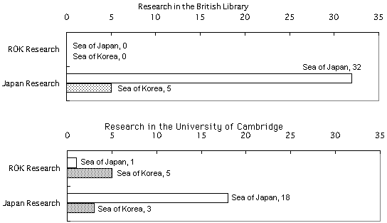
- Based on the Japanese research, the conclusion is as follows:
(1) According to researches by Japanese scholars, various names were used for the area of the Sea of Japan, in European maps prior to the end of the 18th century, including the "Sea of Japan," "Sea of Korea," and "Oriental Sea. *3" (Refer to the pamphlet by the Ministry of Foreign Affairs "Sea of Japan.")
(2) The Japanese study confirmed that the overwhelming majority of the maps published in Europe after the end of the 18th century, use the name "Sea of Japan" (32 maps or 86% of those in the British Library, and 18 maps or 86% in the University of Cambridge carry the name "Sea of Japan").
(3) Accordingly, this confirms the assertion by Japan that the name "Sea of Japan" became established and accepted in Europe from the end of the 18th century to the beginning of the 19th century at a time when Japan was still under its policy of isolation, being unable to exert international influence. The research also clarifies that the assertion by the ROK that the name "Sea of Japan" became widely used as a result of Japan's imperialism and colonialism during the first half of the 20th century, has no ground.
Note:
*3) The name "Oriental Sea" used in these maps implied a contrast to the "Western Sea", and it is therefore not rational of the ROK to take this name synonymous with the "East Sea."
Back to Index