
The Study of maps possessed by the British Library and the University of Cambridge
September 2003
1. Purpose of the Study
(1) Japan has consistently asserted the legitimacy of the name "Sea of Japan" and its major grounds are the following three key points.
(a) At present, the name "Sea of Japan" is internationally established.
(b) Historically, the name "Sea of Japan" became established and accepted in European maps since the beginning of the 19th century.
(c) In view of the methodology for geographical naming, the name "Sea of Japan" is appropriate.
(2) Regarding the historical perspective mentioned above in 1.(b), two researchers at the Geographical Survey Institute studied over 200 antique maps published in Europe. As a result, they discovered that until the late 18th century, various names were used to refer to this sea, such as the "Sea of China," "Oriental Sea," "Sea of Korea" and "Sea of Japan." However, it has been confirmed that the name "Sea of Japan" came to be used with overwhelming frequency mostly in European maps since the beginning of the 19th century 1. From the end of the 18th century to the beginning of the 19th century French, British, Russian and other explorers investigated the areas surrounding the Sea of Japan and discovered that topographically the Sea of Japan is separated from the Pacific Ocean by the Japanese Archipelago. As a result of this discovery, the name "Sea of Japan" came into regular usage in European maps. This view is supported by many researchers.
Notes:
1) Refer to the pamphlet by the Ministry of Foreign Affairs "Sea of Japan." ![]()
(3) In order to further investigate the validity of the above assertion, the Ministry of Foreign Affairs decided to conduct a field study to see whether or not the name "Sea of Japan" is established and accepted in European maps, particularly those that were published in the early to mid-19th century. This study was conducted at the British Library and the University of Cambridge, both of which have a wealth of cartographical references.
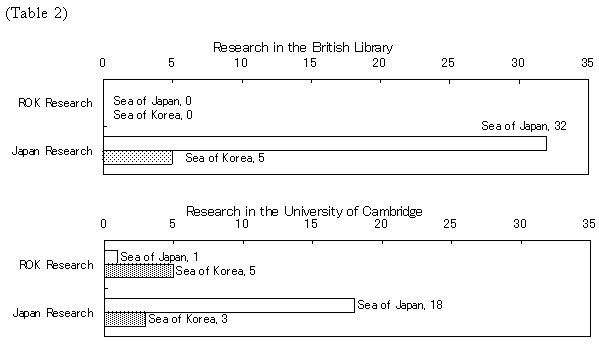
(4) the background of the study is the Republic of Korea's (ROK) assertion that the name "Sea of Japan" became dominant as a result of Japan's imperialism and colonialism during the first half of the 20th century and that both the "East Sea" and "Sea of Japan" were widely used in world maps until the mid- to late 19th century. The ROK cited its own study of antique maps in the British Library and the University of Cambridge as the basis of its claims. According to the study by the ROK, no maps containing the areas surrounding the Sea of Japan were found among those published between 1801 and 1861 and held by the British Library 2. Among the six maps in the same period held by the University of Cambridge, five used the name "Sea of Korea" and one used the name "Sea of Japan 3."
Notes:
2) Lee Ki-suk, Kim Shin, Soh Jung-chul, "East Sea in World Maps," The Society for East Sea, (Seoul: 2002) pp. 52-112.
3) Ibid: pp. 113-126.
2. Overview and Results of the Study
(1) Overview of the Study
From October to December 2002, the Ministry of Foreign Affairs conducted a study of maps held by the British Library, and from December 2002 to June 2003, it conducted a study of maps held by the University of Cambridge. The study was undertaken as follows.
(a) Investigators from the Embassy of Japan in the United Kingdom were dispatched to the British Library and the University of Cambridge. Using records of collected items, they studied maps published between 1801 and 1861 that had the possibility of showing the areas surrounding the Sea of Japan.
(b) The investigators actually surveyed the maps that met the requirements and confirmed whether or not the maps mentioned the Sea of Japan.
(c) The investigators compiled a list of maps that they surveyed and obtained photographs of each map.
(2) Results of the Study
The results of the study are as follows.
(a) Results of the study concerning maps held by the British Library
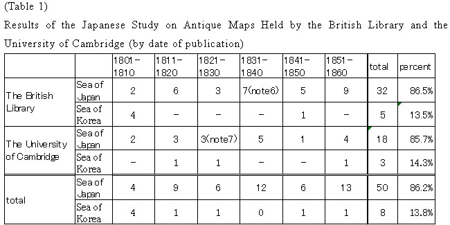
- It was confirmed that 37 maps containing the areas surrounding the Sea of Japan were found among the antique maps published between 1801 and 1861 and held by the British Library 4. This completely invalidated the results of the ROK study, which said that none of the antique maps published during this period contained the areas surrounding the Sea of Japan.
- Among the 37 maps, 32 maps described the area as the "Sea of Japan" (Mer du Japon, etc.) in the local language and five maps described it as the "Sea of Korea" (Gulf of Corea, Mer de Coree, etc.) (see Attached List 1). Furthermore, none of the maps contained the name "East Sea."
- The 37 maps were published in the following countries: United Kingdom (15 maps), France (10 maps), Germany (7 maps), Italy (2 maps), Austria, the Netherlands and Japan (1 map each).
(b) Results of the study concerning maps held by the University of Cambridge
- It was confirmed that 21 maps containing the areas surrounding the Sea of Japan were found among the antique maps published between 1801 and 1861 5. This largely contradicted the results of the ROK study, which said that only six antique maps published during this period contained the areas surrounding the Sea of Japan.
- Among the 21 maps, 18 maps described the area as the "Sea of Japan" in the local language and three maps described it as the "Sea of Korea" (see Attached List 2). Furthermore, none of the maps contained the name "East Sea."
- The 21 maps were published in the following countries: United Kingdom (10 maps), France (4 maps), Germany (3 maps), Italy (2 maps), the Netherlands and Japan (1 map each).
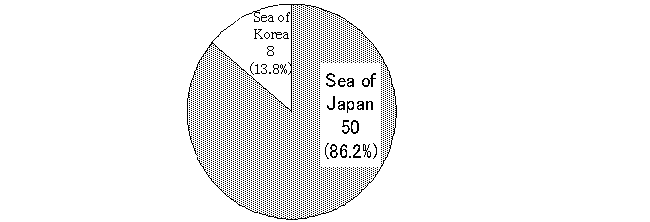
(c) Table 1 shows the results of the study according to the date when the map was published. From this table, it is clear that barring a few exceptions, the name "Sea of Korea" is frequently used in maps published in European countries in the first decade of the 19th century, after which the name "Sea of Japan" is used with overwhelming frequency. In addition, Table 2 illustrates the differences between the results of the studies conducted by the ROK and Japan.
 |
 |
 |
Notes:
4) According to the British Library's records, there were 36 maps and atlases that met the requirements. However, one of the maps was not included in the total, for it was a duplicate. Moreover, there were two atlases with two maps of the areas surrounding the Sea of Japan, but since each of the atlases was counted as one map, the total number was 37.
5) According to the University of Cambridge's records, there were 25 maps and atlases that met the requirements. However, four of the maps were not included in the total, for they were duplicates.
6) Two maps, whose exact date of publication was unclear except that they were published between 1833 and 1853, were placed in the 1831-1840 category for the sake of convenience.
7) One map, whose date of publication is believed to be 1830, was placed in the 1821-1830 category for the sake of convenience.
3. Conclusion
Based on the Japanese research, conclusions are as follows.
(1) The Japanese study confirms that the overwhelming majority of the maps published in Europe after the end of the 18th century used the name "Sea of Japan" (32 maps, or 86.5% of those in the British Library, and 18 maps or 85.7% in the University of Cambridge carried the name "Sea of Japan" None of the maps contained the name "East Sea").
(2) Thus, this study of antique maps published in Europe and held in the British Library and the University of Cambridge confirms Japan's assertion that the name "Sea of Japan" became established and accepted in Europe from the end of the 18th century to the beginning of the 19th century at a time when Japan was still under its policy of isolation, being unable to exert international influence. Furthermore, this study also clarifies : the assertions of the ROK, that the name "Sea of Japan" became dominant as a result of Japan's imperialism and colonialism during the first half of the 20th century and that both the East Sea and Sea of Japan were widely used in world maps until the mid- to late 19th century, are groundless.
Back to Index