
Issue of the Name of the Sea of Japan
Overview of study of maps possessed by the Bibliotheque Nationale de France
(March 2004)
- From October 2003 to January 2004, the Ministry of Foreign Affairs conducted a study of the maps possessed by the Bibliotheque Nationale de France that were published mainly in Europe between the 16th and 19th century concerning the naming on those maps of the maritime region known as the Sea of Japan. The study was undertaken as a means of confirming the assertion of Japan that "historically, the name 'Sea of Japan' became established and accepted in European maps from the beginning of the 19th century."
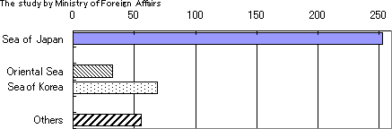
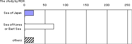
- In response the Republic of Korea (ROK) has asserted that "the name the 'Sea of Japan' came into dominant use as a result of Japan's imperialism and colonialism during the first half of the 20th century" *1, and that "from the 17th to 19th century, westerners used various names for this sea area, with references to Korea being most frequently found on maps." *2 The ROK cites an independently implemented study of the old maps possessed at the Bibliotheque Nationale de France as the basis for these statements. According to the same study by the ROK, of 515 maps examined that were published between the 16th and 19th century, a name was recorded for the region of the Sea of Japan on 115 maps, of which 71, or 62% bore the name "Mer de Coree" (Sea of Korea) or "Mer Orientale" (East Sea), and 22, or 19% bore the name "Mer du Japon" (Sea of Japan). *3
Notes:*1) Lee Ki-suk, Kim Shin, Soh Jung-chul, "East Sea in World Maps", The Society for East Sea. (Seoul: 2002) pp. 95-112. *2) The Ministry of Foreign Affairs and Trade, The Ministry of Maritime Affairs and Fisheries. The Korean Overseas Information Service of the Government Information Agency, "EAST SEA: The Name East Sea Used for Two Millennia." (Republic of Korea: April 2003) pp. 4-11. *3) Chosunilbo, March 11, 2003, JoongAngIlbo, March 11, 2003. - The findings of the study undertaken this time by the Ministry of Foreign Affairs concerning the maps possessed by the Bibliotheque Nationale de France are as follows:
(1) The results of study of 1,495 maps possessed by the Bibliotheque Nationale de France and published between the 16th and 19th century show that of 407 maps for which a name was recorded, 249, or 61% bore the name "Sea of Japan" and 60, or 15% bore the name "Sea of Korea." No maps were found that bore the name "East Sea." *1 (See attached list )
)
(2) Of the maps published in the first half of the 19th century, 90.0% or 99 maps bore the name "Sea of Japan" and of the maps published in the latter half of the 19th century 100% or 105 maps bore the same name.
Notes:
*1) The ROK emphasizes that the name "East Sea" implies a "sea to the East" looking from the Eurasian continent. However, "Oriental" is the antonym of "Occidental" and therefore should not be used in parallel with "East" that simply represents a direction. Accordingly, although in the study undertaken by the ROK "Mer du Orientale" was classified as "East Sea," the study undertaken by the Ministry of Foreign Affairs classifies it as "Oriental Sea."
(Table) Result of Study of Maps Possessed by the Bibliotheque Nationale de France *11550-
16001601-
16501651-
17001701-
17501751-
18001801-
18501851-
1900un-
known17C 18C 19C total per-centage Sea of
Japan0 2 12 9 10 99 105 10 0 5 2 254 62.0% Oriental
Sea0 6 8 3 0 0 0 8 6 1 0 32 7.8% Sea of
Korea2 0 1 12 36 6 0 7 3 1 0 68 16.6% others 5 19 6 3 2 5 0 4 11 1 0 56 13.7% total 7 27 27 27 48 110 105 29 20 8 2 410
(Graph) Result of Study of Maps Possessed by the Bibliotheque Nationale de France (Comparison of the studies undertaken by Japan and the ROK)
Notes:
*1) Of the maps possessed by the Bibliotheque Nationale de France, there were four maps the period of publication of which could not be precisely identified. For the sake of convenience these maps were classed as follows: a map published in the 1650s was classified as latter half 17th century, a map published between 1737 and 1772, together with another map published in the latter half of the 18th century were both classed as latter 18th century, and a map published in the 1880s was classified as latter half 19th century.
two maps bearing the name "Sea of Japan - Oriental Sea" were included in the "Sea of Japan" classification, and five maps bearing the name "Oriental Sea - Sea of Korea" were included in the "Sea of Korea" classification. Three maps bearing the name "Sea of Japan - Sea of Korea" were included in both classifications. As a result of this data management, the table and graph show 254 maps bearing the name "Sea of Japan," 68 maps bearing the name "Sea of Korea," and a total of 410 maps. - The conclusion of the study undertaken by the Ministry of Foreign Affairs is as follows:
(1) In European maps published until the 18th century, various names were used for the area of the Sea of Japan, including "Sea of Japan" "Sea of Korea" "Oriental Sea" and "Sea of China."
(2) The results of this study confirm that from the 19th century onwards, on most maps published in Europe the name most commonly used is the "Sea of Japan," thus attesting to Japan's assertion that "the name 'Sea of Japan' became established and accepted in Europe from the 19th century, at a time when Japan, due to a policy of isolation, could not exert any international influence."
(3) The study of the maps possessed by the Bibliotheque Nationale de France undertaken by the ROK was insufficient in that it used only a selection of the maps possessed there. It is also clear from this study that the basis for the ROK assertions that "the name the 'Sea of Japan' came into dominant use as a result of Japan's imperialism and colonialism during the first half of the 20th century," and that "from the 17th to 19th century, westerners used various names for this sea area, with references to Korea being most frequently found on maps" are in fact groundless.
Back to Index